
JUN 17 | 8:30 AM

Al suscribirte, aceptas la política de privacidad. Cancela tu suscripción en cualquier momento.
Barnebys HQ
Brahegatan 10
BOX 5038
114 37 Stockholm
Todas las subastas / Libros, mapas, papel & manuscritos / Mathew Carey's General Atlas, 1796 - America's First World Atlas
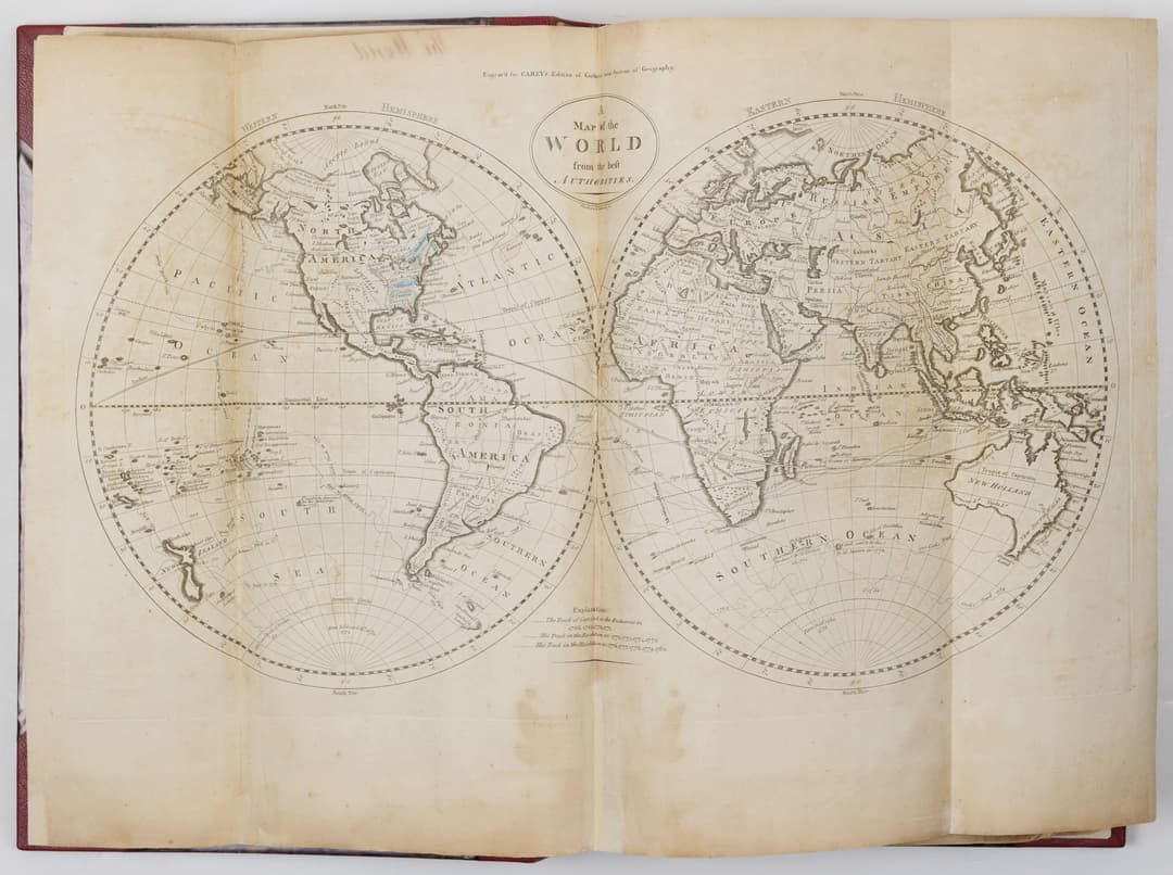
CAREY, Mathew (1760–1839). Carey's general atlas; containing: 1. Map of the world, 2. Chart of do. 3. Europe, 4. Sweden, Denmark, and Norway, 5. Russia, 6. Scotland, 7. England and Wales, 8. Ireland. . . 19. Asia, 20. China, 21. Hindostan, 22. Africa, 23. British settlements in America, 24. United States, 25. Vermont, 26. New-Hampshire, 27. Province of Maine, 28. Massachusetts, 29. Rhode-Island, 30. Connecticut, 31. New-York, 32. New-Jersey, 33. Pennsylvania, 34. Delaware, 35. Maryland, 36. Virginia, 37. North-Carolina, 38. South-Carolina, 39. Georgia, 40. Kentuckey, 41. Tennassee, 42. South America, 43. West-Indies. 44. Countries round the north pole, 45. Captain Cook's discoveries. Philadelphia: Mathew Carey; May 1, 1796. First edition. AMERICA’S FIRST WORLD ATLAS Folio (14 ¾” x 9 9/16”): π1 (title-leaf). With 49 (of 45) engraved maps, hand-colored in outline; of which 25 are double-page, 21 folding and 3 single. Bound in modern half red morocco over modern boards (by Brockman). On the spine, five raised bands. Title gilt to the second panel. Conserved in 2024 by Brockman (full report available). All maps (re-)inserted on stubs, with repairs and filled losses, particularly at the edges. Damp-staining, soiling and tanning throughout. Maps numbered in an old hand verso, the first 7 additionally captioned verso. A large loss to the right edge of the North-Carolina map (no. 37; with a second, uncolored example of the map supplied following). The “British settlements in America” map (no. 23) followed by Samuel Lewis’s 1812 map of the same subject and on the same model. Two additional maps of Indiana inserted at the end: John Scott’s 1826 map and another from a (Massachusetts?) newspaper of 1834. Ink annotations to the maps of Maine and Massachusetts, giving county names. Ink-stamp of “D.Woodbridge.jr” to the title-page with “NO8” in ink manuscript besides. Graphite ownership signature of John Morgan Woodbridge to the tail of the title-page as well as to the verso of the rear (old) free end-paper, as well as his birth-date and university dates, all graphite. Mathew Carey (1760–1839), despite being born in Ireland, is a consummate American. Trained in Dublin as a printer, he worked for a radical newspaper advocating Irish independence along the same lines as America’s. After printing an open letter from Benjamin Franklin in the paper, he came to know the great man while exiled to Paris for his criticism of dueling (an irony that will become evident in the discussion below), and worked for Franklin there. Carey emigrated to Philadelphia in 1784, where through Franklin’s patronage he was able to set up a publishing house and bookshop in the academically fecund “Athens of America.” Through the 1790’s, America had largely relied on European cartographic sources, even using British maps in the War of Independence. Carey, a true believer in the power of the fourth estate, knew that success and power would come with American printings of books rather than imports from across the Atlantic. Carey republished Guthrie’s 1770 New System of Modern Geography in 1794, which boasted a supplement volume with several dozen maps and charts. The book was wildly popular in the growing South and West, and, based on that volume’s success, Carey in 1796 undertook to print the first stand-alone world atlas made in America: Carey’s General Atlas. With about half of the maps showing the wider world — the American maps are highlighted with manicules on the title-page — this was the first time an American could forge a view of the world stage onto which the new nation had stepped. Dudley Woodbridge Jr. (1747–1823) was the son of a Connecticut doctor, and served as the first postmaster of Norwich, CT. He went west to Marietta, Ohio the first settlement in the post-1787 Northwest Territory (bounded by the Ohio River southeast, the Mississippi west and the Great Lakes north), and set up there its first general store. The present atlas can be seen as a guide to the expanding nation, but the story of its importance does not stop with the Woodbridges (the atlas was owned also by Woodbridge’s grandson, John Morgan Woodbridge (1817–1880), who was educated at Oxford, Yale and Princeton). Woodbridge went into business with Harman Blennerhassett, an advocate for Irish independence as Carey was, who settled with his wife (who was his niece) about a dozen miles downstream the Ohio from Marietta. Blennerhassett welcomed former Vice President Aaron Burr, and with Woodbridge’s financial support advanced the so-called Burr conspiracy: to separate the Louisiana purchase from the United States and, with British support, to establish an independent republic that he would lead. Although he was acquitted, Burr was widely viewed as a traitor, ending his political career and sending him into exile in Europe. Thus the atlas can be seen as a tool of planning, one doubtless used by Woodbridge and perhaps even Burr in an attempt to divert Manifest Destiny. Not in Howes; Phillips, Library of Congress 683.
Estimación:€34,328.04
To the auctionVer todos los artículos deArader GalleriesoLibros, mapas, papel & manuscritos

GENERALSTABEN MAPP, "Carlos XII en el campo de batalla", mapa, 1919
09/02/2026
€186
Detalles

BOK, "SVERIGES INDUSTRI DESS STORMÄN OCH BEFRÄMJARE".
06/06/2026
€29
Est.: €56
Detalles
JUN 17 | 8:30 AM

JUN 13 | 3:00 PM

JUN 6 | 4:00 PM

Test lot 1 - Anglo-Saxon England, Continental Phase (695-740), Series
08/15/2026
€116
Detalles
SELIGMANN, illustration ur "Sammlung verschiedener ausländischer und
06/06/2026
€47
Est.: €93
Detalles
